Free Shipping on orders over $500



Topcon DT207 Digital Theodolite Kit with 7 Second Accuracy - Model
7 seconds (both horizontal and vertical circles) Accuracy
Hold grade with a 7 seconds (both horizontal and vertical circles) accuracy rating.
Battery
Runs on Rechargeable NiMH pack providing 11 hours continuous use for jobsite flexibility.
Authorized Topcon Dealer
Genuine, factory-fresh Topcon equipment with legitimate firmware and calibration documentation.
Same-Day Shipping
In-stock orders placed before 2 PM CT ship the same day.
Authorized Dealer
Genuine equipment sourced straight from manufacturer partners.
Ships Same Day
Orders placed before 2 PM CT leave the dock today.
Genuine Gear
Factory-fresh, authentic units with legitimate firmware.
Best-Price Guarantee
Authorized-dealer pricing on every unit — request a quote anytime.
What's In The Box
Included Components
Everything that ships with the Topcon DT207 Digital Theodolite Kit with 7 Second Accuracy - Model — 7 items.
- 7-Second Digital Theodolite
- Plumb Bob
- Tool Kit
- Lint Free Lens Cloth
- Waterproof Protective Cover
- Hard Carrying Case
- Owner's Manual
Kit Builder
Not sure what goes with this accessory?
Answer a few job questions and our Kit Builder assembles the full setup — receiver, rod, tripod, and case matched to your workflow.
Quick Answer
What is the Topcon DT207?
The Topcon DT207 delivers 7-second angular accuracy for surveyors and municipal engineers requiring precise angle measurements on boundary surveys and infrastructure projects. A step up in accuracy from the DT209 for demanding applications.
What contractors use this accessories for
Municipal Boundary Survey
Major Infrastructure Layout
Precision Building Alignment
Product Description
Overview
The Topcon DT207 Digital Theodolite delivers 7-second accuracy for surveyors, municipal engineers, and construction layout teams requiring precise angle measurements on boundary surveys, building alignments, and infrastructure projects. This complete kit includes a heavy-duty aluminum tripod, fiberglass leveling rod, and hard-shell carrying case, providing everything needed for immediate deployment on property corners, foundation stakeout, and as-built verification work. The backlit LCD display and absolute encoders eliminate resetting after power cycles, while the IP66 rating protects internal optics and electronics during dust storms and rain delays. Surveyors working subdivision plats, right-of-way documentation, and MEP coordination use the DT207 when total stations exceed budget but accuracy can't be compromised.
Key Specifications
- Angle Accuracy: 7 seconds (both horizontal and vertical circles)
- Telescope: 30x magnification, 45mm objective lens, 1.3° field of view
- Minimum Focus: 3.3 feet (1 meter)
- Display: Dual-sided backlit LCD showing angles in degrees/minutes/seconds or decimal degrees
- Leveling: Plate bubble sensitivity 30 seconds per 2mm, circular bubble 8 minutes per 2mm
- Environmental Rating: IP66 dust-tight and rain-resistant
- Battery: Rechargeable NiMH pack providing 11 hours continuous use
- Operating Temperature: -4°F to 122°F (-20°C to 50°C)
- Weight: 10.6 lbs (4.8 kg) instrument only
- Optical Plummet: 3x magnification, ±0.3mm at 1.5m accuracy
What's in the Kit
- Topcon DT207 Digital Theodolite: 7-second instrument with dual-sided display and absolute encoders
- Aluminum Tripod: Heavy-duty flat-head tripod with quick-clamp legs and adjustable shoulder strap
- 13-Foot Fiberglass Leveling Rod: Graduated measuring stick for elevation differentials and stakeout verification
- Hard-Shell Carrying Case: Impact-resistant foam-lined case protecting optics during transport
- Rechargeable Battery Pack: NiMH power cell with AC wall charger (110V)
- Tool Kit: Adjustment screwdrivers, hex keys, and lens cloth
- Dust Cover: Weather-resistant fabric cover for instrument protection when mounted
- Plumb Bob: Brass plumb bob with string for tribrach centering over control points
- Rain Cover: Clear vinyl shield protecting display and keyboard during wet conditions
- Instruction Manual: Setup, operation, and field calibration procedures
Job Applications
- Property Boundary Surveys: The 7-second accuracy ensures angle closures meet ALTA/NSPS standards on subdivision plats and legal descriptions where boundary disputes trigger litigation.
- Building Layout and Alignment: Vertical and horizontal angle measurements verify column plumbness, facade alignment, and floor-to-floor elevation consistency on multi-story construction where tolerance stack-up causes cladding gaps.
- Pipeline and Utility Corridor Stakeout: Precise deflection angles at curve points prevent easement violations and reduce rework when underground infrastructure must follow recorded centerlines within narrow rights-of-way.
- Bridge and Structural Monitoring: Repeated angle measurements detect settlement, deflection, or rotation in bridge piers, retaining walls, and towers where movement indicates structural distress requiring engineering intervention.
- Tower Plumbness and Verticality Checks: Dual-axis vertical angle readings confirm communication towers, wind turbines, and stacks remain within manufacturer plumbness specifications after installation or storm events.
- As-Built Documentation: Angle and distance combinations (with tape measurements) create accurate record drawings of completed improvements when GPS canopy interference prevents rover positioning and client budgets exclude total station rental.
Compatible Accessories
- Topcon Tribrach with Optical Plummet – Interchangeable mounting base for switching between theodolite and GPS receiver on single control point
- SECO Heavy-Duty Wooden Tripod – Stability upgrade for windy conditions and long observation sessions requiring vibration damping
- CST/Berger 25-Foot Telescoping Grade Rod – Extended reach for vertical angle shots on tall structures and slope staking
- Topcon External Battery Pack – Cold-weather backup power maintaining operations below 0°F when internal NiMH capacity drops
- Prism Pole and Tribrach Target Set – Reflective targets improving sighting precision at distances beyond 200 feet in hazy conditions
Related Guides
- How to Level and Calibrate Your Theodolite for Accurate Measurements
- Theodolite vs. Total Station: Which Instrument to Choose for Your Survey Project
- Measuring Horizontal and Vertical Angles: Step-by-Step Field Procedures
- Troubleshooting Theodolite Accuracy Problems and Calibration Drift
Frequently Asked Questions
- What's the difference between 7-second accuracy and the 20-second theodolites?
- The DT207's 7-second accuracy provides approximately three times tighter precision than 20-second instruments, critical when angle errors compound over distance. On a 500-foot shot, 7-second error creates ±0.017-foot lateral displacement versus ±0.048 feet with 20-second instruments—the difference between meeting boundary survey standards and failing closure tolerances on legal plats. Choose 7-second theodolites for property surveys, precise construction layout, and any application where angle measurements establish legal boundaries or structural positioning requiring sub-0.02-foot accuracy.
- Does this theodolite measure distances or just angles?
- The DT207 measures horizontal and vertical angles only—it does not include electronic distance measurement (EDM) capabilities. You'll combine angle readings with steel tape measurements, laser distance meters, or stadia rod readings to calculate coordinates and distances. This configuration suits surveyors who already own distance measurement tools or work on projects where angle verification (building plumbness, column alignment, monitoring) matters more than distance. Upgrading to a total station adds EDM but typically doubles the investment.
- Can I use this theodolite in the rain or dusty conditions?
- Yes, the IP66 environmental rating means the DT207 withstands rain, blowing dust, and job site debris without internal contamination. The sealed keyboard and display prevent water intrusion during storms, while protected optical pathways block dust on grading sites and demolition projects. However, IP66 protection requires you close all battery compartment doors and keep the objective lens cap attached during transport. The included rain cover adds extra display protection during heavy downpours, and you should still wipe external lenses before precision observations to prevent water droplets from distorting crosshair images.
- How long does the battery last, and can I swap batteries in the field?
- The rechargeable NiMH battery provides approximately 11 hours of continuous angle measurement under normal temperatures (68°F). Cold weather below 32°F reduces runtime to 6-8 hours as battery chemistry slows. The battery removes from the instrument base for charging, allowing you to carry a spare for multi-day projects or winter work where capacity drops. The included AC charger fully recharges depleted batteries in 4 hours. For extended backcountry surveys without AC power, consider adding solar charging systems or carrying three batteries on rotation—two in the field while one charges via vehicle inverter during lunch breaks.
Why This Equipment
Authorized Dealer
Genuine, factory-fresh inventory with legitimate firmware and calibration documentation.
Same-Day Shipping
In-stock orders placed before 2PM ship same day from our Texas warehouse.
Expert Support
Call or chat with a contractor equipment specialist before and after your purchase.
Free Shipping
Free ground shipping on orders $99+ to the continental US.
Professional-grade equipment, authorized dealer pricing.
The tools contractors trust on municipal infrastructure, commercial projects, and high-tolerance earthwork aren't available at hardware stores — and they shouldn't be. This equipment is engineered for professionals, and buying it through an authorized dealer means you get full manufacturer support when it matters.
Express Tools carries only factory-fresh inventory from brands contractors specify by name. No gray-market product, no import-spec units, just authentic gear with legitimate firmware and calibration documentation.
Same-day shipping on in-stock items, expert support before and after the sale, and a 30-day return window on most products. If you have questions about specs, compatibility, or applications, call us — we know this equipment.
Specifications
Technical Specs
Manufacturer data and field-verified measurements.
| Angle Accuracy | 7 seconds (both horizontal and vertical circles) |
|---|---|
| Telescope | 30x magnification, 45mm objective lens, 1.3° field of view |
| Minimum Focus | 3.3 feet (1 meter) |
| Display | Dual-sided backlit LCD showing angles in degrees/minutes/seconds or decimal degrees |
| Leveling | Plate bubble sensitivity 30 seconds per 2mm, circular bubble 8 minutes per 2mm |
| Environmental Rating | IP66 dust-tight and rain-resistant |
| Battery | Rechargeable NiMH pack providing 11 hours continuous use |
| Operating Temperature | -4°F to 122°F (-20°C to 50°C) |
| Weight | 10.6 lbs (4.8 kg) instrument only |
| Optical Plummet | 3x magnification, ±0.3mm at 1.5m accuracy |

Built for Topcon equipment owners
Run the jobsite around your equipment
Gradelog is the AI field platform for contractors — grade shots, photo documentation, calibration tracking, and as-built reports, all tied to your gear.
- Equipment & calibration tracking
- Photo + grade documentation
- AI field assistant, 8 languages
Customers Also Bought
Related Products
More in Accessories
View all
Leica Detect DD120 (60Hz) Plumbers Package - 6014159
$2333.00
View Product
DT205 Digital Theodolite Kit with 5 Second Accuracy - Model 303216101
$4175.00
View Product
Spectra Precision 1244 T-Bar for Pipe Laser
$895.00
View Product
Spectra 010542-99 Charger Adapter for LR Series Machine Receivers (Fits LR30, LR50 and LR60 Series)
$82.50
View ProductField Calculators
Compare
Guides & Resources
Common Issues & Error Codes
Customer Reviews
No reviews yet — be the first.
Loading reviews…
Topcon DT207 Digital Theodolite Kit with 7 Second Accuracy - Model
$3195.00
Free 14 days with every Express Tools purchase
Your equipment. Your data. All in one place.
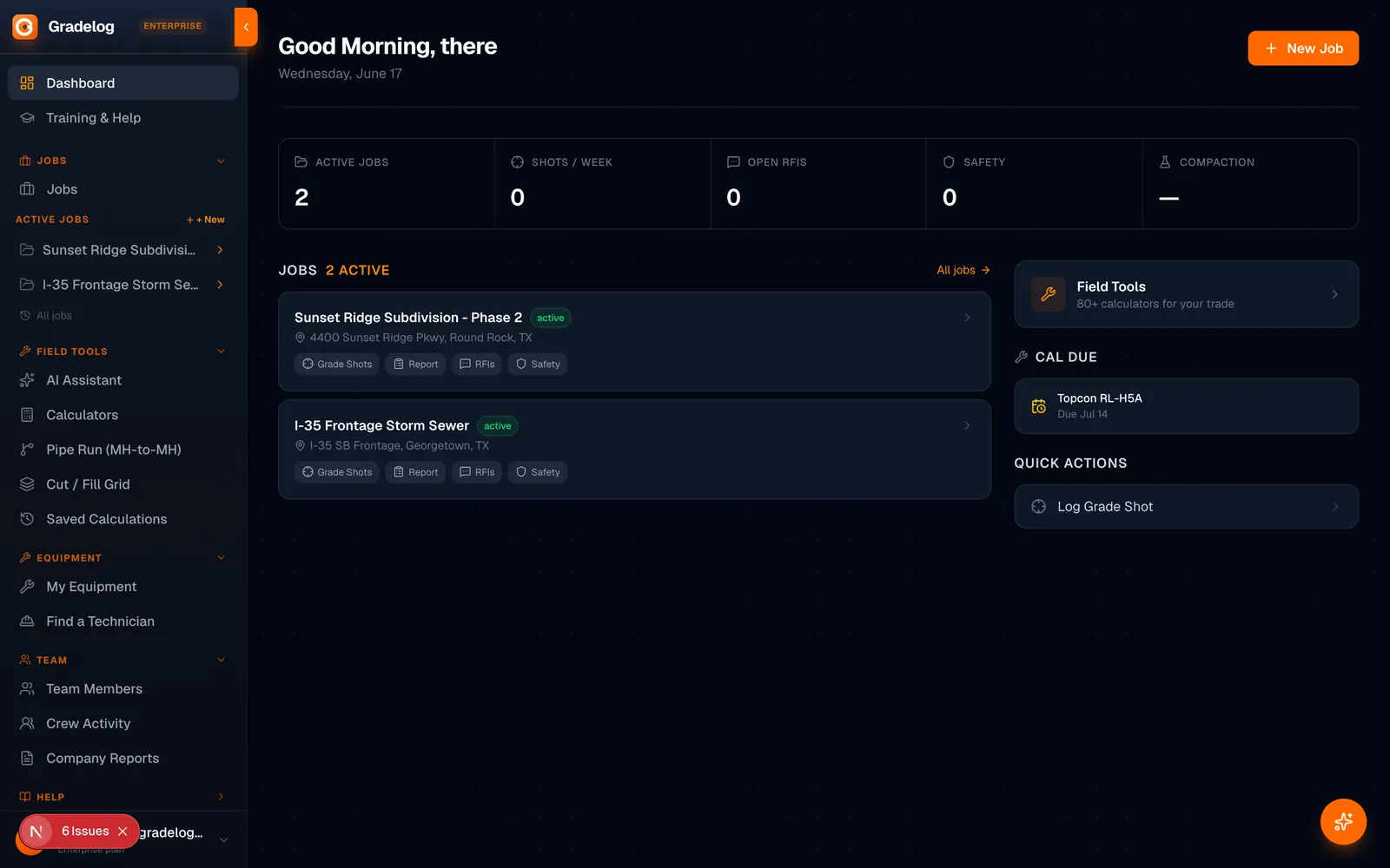
Gradelog is the field-execution platform built for grading and earthwork crews. Log grade shots, track cut/fill, document phases with photos, and generate as-built reports — from the cab to the office.
- Grade shots & cut/fill tracking per job
- Photo documentation by phase, task, and equipment
- As-built reports ready for inspector sign-off
- AI field assistant — troubleshoot on the jobsite
Built by the same team as Express Tools
Try Free →14 days
Free trial
8 languages
Supported
iPhone + Android
Works on